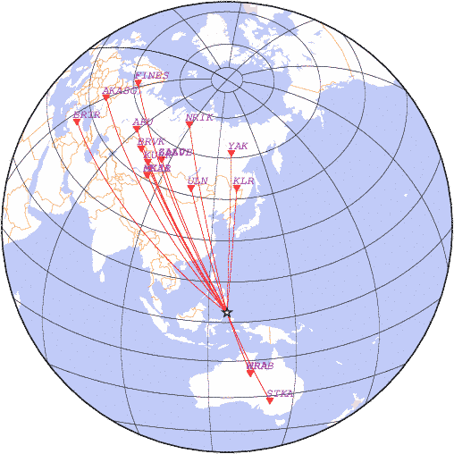
date 2017-09-03 11:55:50, lat 3.71, lon 126.42, depth 60 km, mb: 4.8/9
detemined with station data:
| N | Code | Time | Phase | Delta | Azimuth | Residual | Ms | mb | Network |
|---|---|---|---|---|---|---|---|---|---|
| 1 | WRAB | 12:01:05.5 | P | 24.75 | 162 | -2.5 | - | 4.8 | CAN |
| 2 | WRA | 12:01:05.8 | P | 24.76 | 162 | -2.2 | - | - | CAN |
| 3 | STKA | 12:03:03.9 | P | 38.22 | 159 | -2.5 | - | - | AUST |
| 4 | KLR | 12:04:04.6 | P | 45.59 | 5 | -1.9 | - | 4.4 | OBGSR |
| 5 | ULN | 12:04:16.4 | P | 47.05 | 342 | -1.6 | - | 4.5 | OBM |
| 6 | MK31 | 12:05:34.3 | P | 57.40 | 325 | -1.0 | - | - | NNC |
| 7 | MKAR | 12:05:34.4 | P | 57.58 | 325 | -2.2 | - | 4.9 | NNC |
| 8 | YAK | 12:05:39.4 | P | 58.23 | 2 | -1.4 | - | 5.5 | YAGSR |
| 9 | ZALV | 12:05:54.5 | P | 60.47 | 333 | 0.1 | - | - | RIPT |
| 10 | ZAA0B | 12:05:54.7 | P | 60.47 | 333 | 0.3 | - | - | RIPT |
| 11 | KURK | 12:06:02.9 | P | 61.59 | 328 | -1.2 | - | 5.3 | NNC |
| 12 | BRVK | 12:06:40.0 | P | 67.24 | 327 | -0.7 | - | 4.8 | NNC |
| 13 | NRIK | 12:07:00.0 | P | 70.36 | 346 | 0.4 | - | 4.7 | RIPT |
| 14 | ARU | 12:07:25.1 | P | 74.79 | 328 | -0.9 | - | 4.7 | OBGSR |
| 15 | BRTR | 12:08:45.0 | P | 89.80 | 310 | 0.8 | - | - | ISK |
| 16 | FINES | 12:08:54.0 | P | 91.71 | 332 | 1.5 | - | - | HEL |
| 17 | AKASG | 12:08:50.6 | P | 91.72 | 321 | -2.2 | - | - | NSAU |
|
News |
Catalogs |
Wave Forms |
Alert Service |
Software |
Links |
Srtucture |
Publications |
Conferences |
Announce |
About
© FRC GS RAS 1993-2018 |

